특집논문/SPECIAL EDITIONS
산악지형 내 MANET 기반 드론 전술통신 운용 및 성능 검증
김동환*,**
,
김득화*,†,
신승훈*,
조중영*,
김도영*,
전지훈*,**,
김정훈*,***
Operation and Performance Evaluation of MANET-Based Tactical Drone Communications in Mountainous Terrain
Donghwan Kim*,**,
Deukhwa Kim*,†,
Seunghoon Shin*,
Joongyoung Cho*,
Doyoung Kim*,
Jihoon Jun*,**,
Junghoon Kim*,***
Author Information & Copyright ▼
**Department of Defense AI&Robot Convergence, Kwangwoon University
***Department of Defense Industry AI&Robot Convergence, Kwangwoon University
© Copyright 2026 The Korean Institute of Electromagnetic Engineering and Science. This is an Open-Access article distributed under the terms of the
Creative Commons Attribution Non-Commercial License (http://creativecommons.org/licenses/by-nc/4.0/) which permits
unrestricted non-commercial use, distribution, and reproduction in any
medium, provided the original work is properly cited.
Received: Dec 20, 2025; Revised: Feb 03, 2026; Accepted: Mar 05, 2026
Published Online: Apr 30, 2026
요 약
본 연구는 산악지형 전술 환경에서 MANET 기반 드론 통신 체계의 운용 가능성과 성능 특성을 실증적으로 분석하였다. 산악지형에서 지휘소-중계드론-정찰자산으로 구성된 다중 홉 MANET 구조를 구축하고, 통신 커버리지, 링크 안정성 및 데이터 전송 품질을 평가한 결과, 통신 성능은 노드 간 거리보다 지형에 따른 LOS 확보 여부에 크게 의존함을 확인하였다. 또한 중계드론 위치 조정과 안테나 틸트 최적화를 통해 링크 품질이 유의미하게 개선되었으나, 다중 고해상도 영상 전송 시에는 대역폭 한계로 인한 병목 현상이 발생하였다. 본 연구는 산악지형 전술 환경에서 MANET 기반 드론 통신의 효과성과 한계를 제시하고, 향후 다중 중계 기반 전술 통신 구조 설계를 위한 기초자료로 사용될 수 있다.
Abstract
This study experimentally analyzes the operational feasibility and performance characteristics of a MANET-based drone communication system in mountainous tactical environments. A multi-hop MANET architecture consisting of a command post, relay UAV, and reconnaissance assets is deployed in a mountainous area, and the communication coverage, link stability, and data transmission performance were evaluated. The results indicate that communication performance depends more strongly on terrain-induced line-of-sight (LOS) conditions than on the internode distance. In addition, relay UAV repositioning and antenna tilt optimization significantly improves link quality, whereas bandwidth limitations cause bottlenecks during simultaneous high-resolution video transmission. This study presents the effectiveness and limitations of MANET-based drone communications in mountainous tactical environments and provides a foundational reference for the design of future multirelay tactical communication architectures.
Keywords: MANET; UAV Relay; LOS; Network Performance Evaluation
Ⅰ. 서 론
현대 군 작전 환경은 실시간 ISR(intelligence, surveillance, reconnaissance) 정보를 기반으로 신속한 지휘결심이 요구되며, 유·무인 복합체계의 확대에 따라 전술 통신망의 중요성이 지속적으로 증가하고 있다. 그러나 산악지형에서는 지형 굴곡과 고저 차로 인해 LOS(line-of-sight) 확보가 어렵고, 고정형 통신 인프라 구축에도 한계가 있어 이동성과 자율성을 갖춘 MANET(mobile ad-hoc network) 기반 통신기술의 필요성이 부각되고 있다.
기존 연구들은 MANET의 성능을 개별 요소 중심으로 분석해 왔으나, 실제 군 전술 환경에서 중계드론(UAV)을 활용하여 다중 노드 간 고대역폭 영상 데이터 전송 성능을 현장 전투실험으로 검증한 연구는 시뮬레이션 중심 연구에 비해 연구 비중이 상대적으로 낮았다. 이에 본 연구는 산악지형 실증 실험을 통해 중계드론 기반 전술 MANET의 통신 커버리지와 링크 안정성, 데이터 전송 특성을 분석하고, 향후 전장 네트워크 기반의 작전 개념을 구현하기 위한 전술 통신의 구조 설계 기초자료를 제공하고자 한다.
Ⅱ. 관련 연구
2-1 UAV 기반 MANET 통신
UAV를 전술 통신망의 중계 노드로 활용하는 연구는 산악 등 지형 제약 환경에서 MANET 구조의 연결성 확보를 중심으로 진행되어 왔다. 참고문헌 [1]은 산악 지형 기반 MANET 시뮬레이션을 통해 지형 차폐로 인한 성능 저하를 UAV 고도 조정으로 완화할 수 있음을 보였고, 참고문헌 [2]는 3차원 지형 데이터를 활용해 aerial relay 배치가 네트워크 연결성 향상에 유효함을 제시했다. 다만 기존 연구는 시뮬레이션 중심이어서 실제 전술 환경에서의 통신 품질 및 고대역폭 데이터 전송 성능에 대한 실증 또는 검증에 관한 연구는 많지 않다.
2-2 FANET 기반 중계 UAV 및 네트워크 최적화
FANET 기반 연구에서는 중계 UAV 선택 및 배치 최적화를 통해 네트워크 안정성을 향상시키는 접근이 주로 다뤄졌다. 참고문헌 [3]은 거리와 링크 품질을 반영한 확률론적 중계 UAV 선택 기법이 안정성에 기여함을 보였으며, 참고문헌 [4]는 산악 지형에서 가시성(visibility) 확보를 고려한 경로 계획 및 중계 위치 선정이 통신 성능에 미치는 영향을 분석했다. 그러나 UAV-지상자산-지휘소 간 통합 운용을 전제로 한 실증적 성능 평가에 관한 연구 사례는 없는 것으로 판단된다.
Ⅲ. 실험 구성 및 환경
3-1 운용 구조 및 장비 제원
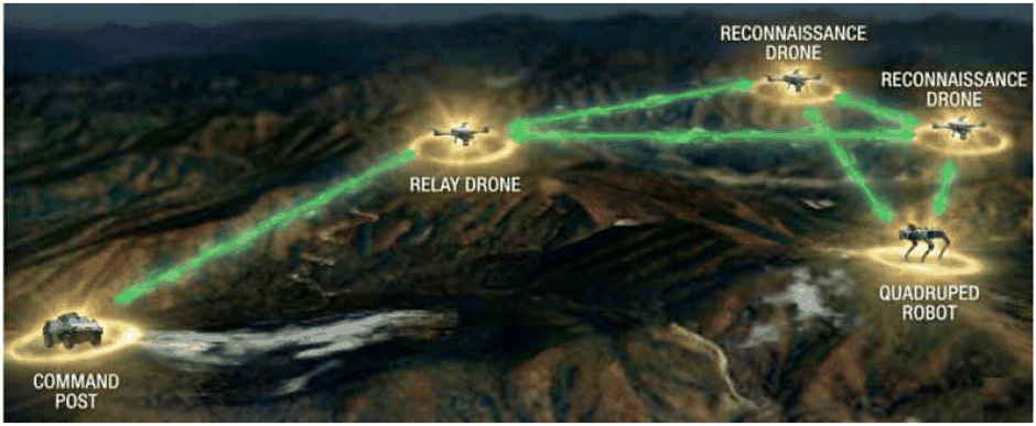
본 연구에서의 실험은 MANET 통신 기반으로 지휘소↔중계드론↔정찰자산(정찰드론, 사족 로봇)으로 이어지는 다중 홉(multi-hop) 구조로 진행되었으며, 본 실험에 투입된 임무장비별 장착 스펙과 임무수행 방안은 표 1과 같다(그림 1).
표 1. | Table 1.
임무장비별 장착 스펙 및 임무수행 방안 | Installation specifications and mission execution methods by mission equipment.
| Category |
Details/specification |
Command post |
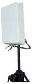
Install a directional antenna for high-power MANET (20 W) and long-range communications |
<Specification>
Waveform: MN-MIMO (mobile networked MIMO)
Frequency: 2,200~2,500 MHz
Latency: mean 7 ms @20 MHz BW
Sensitivity: −102 dBm@5 MHz BW
Power consumption: Max. 95 W |
Relay UAV |
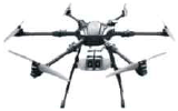
Equip a high-power MANET radio (20 W) and four omni-directional antennas; serve as a relay node between the command post and reconnaissance assets |
<Relay UAV specification>
Hexacopter, Payload: 10 kg, Flight time: 30 Minutes, RTK-GNSS, Autonomous flight mode, GCS S/W: QGC, Protocol: MAVLink Equip a MANET radio (10 W) and two omni-directional antennas; collect video and measurement data via EO/IR cameras and spectrum analysis |
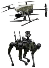
Recon UAV/quadruped robot |
<MANET specification>
Waveform: MN-MIMO (mobile networked MIMO)
Frequency: 2,200~2,500 MHz
Latency: 7 ms average (20 MHz BW)
Sensitivity: −99 dBm@5 MHz BW
Power consumption: 65 W (MAX) |
<Recon UAV specification>
Quadcopter, EO/IR Camera with LRF (EO: 4K, 30x Zoom, IR: 640×512, 8x Zoom), Payload: 3 kg, Flight time: 30 minutes, RTK-GNSS, Autonomous flight mode, GCS S/W: QGC, Protocol: MAVLink |
<Quadruped robot specification>
Weight: 51 kg, Payload: 10 kg, Max. Speed: 2.4 m/s,
Operating time: 3 hours, Standby time: 21 hours, Depth 4EA/RGB 5EA Camera, Blind mode, GPS/Map-based autonomous driving |
Download Excel Table
Ⅳ. 실증 실험 및 결과 분석
4-1 기간별 실험 결과 요약
본 연구는 거리, 고도, 지형 차폐 여부에 따른 MANET 기반 통신기술의 품질 변화를 분석하였다. 각 실험에서는 지휘소–중계드론, 중계드론–정찰자산간 SNR과 RSSI를 측정하여 링크 안정성을 측정하고, 지형 영향 및 장비 설정 변화에 따른 성능 차이를 검토하였다.
4-1-1 1차 실험
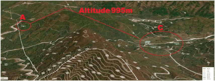
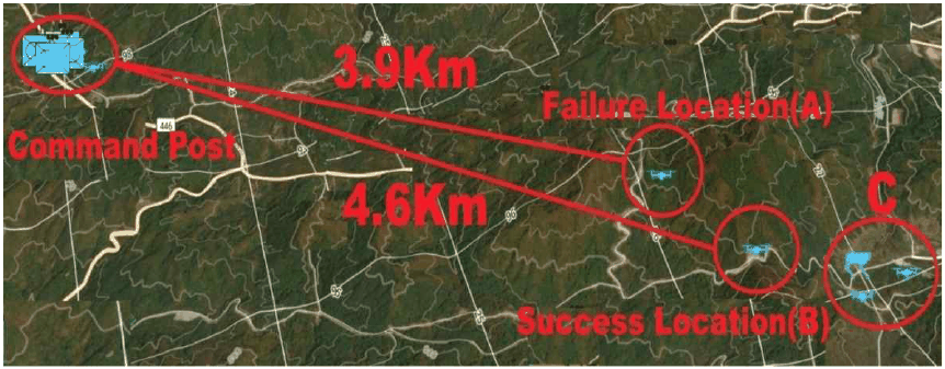
중계드론을 그림 2의 A지점(B지점 보다 지휘소 방향으로 650 m 전진된 위치, A의 고도 906 m, 드론 지상고 110 m(드론 해발고 1,016 m)에 배치하고 지휘소부터 거리 3.96 km 조건에서 실험을 수행하였다(드론 지상고: 드론이 지면으로부터 수직으로 떨어진 거리, 해발고: 평균 해수면 기준 높이).
지휘소–중계드론 간 링크: SNR 20 dB 수준에 RSSI −60 dBm으로 측정(6 dBi omni antenna×4).
중계드론-정찰 링크: SNR 11 dB 수준에 RSSI −79 dBm으로 불연속적·반복적 링크 단절 발생.
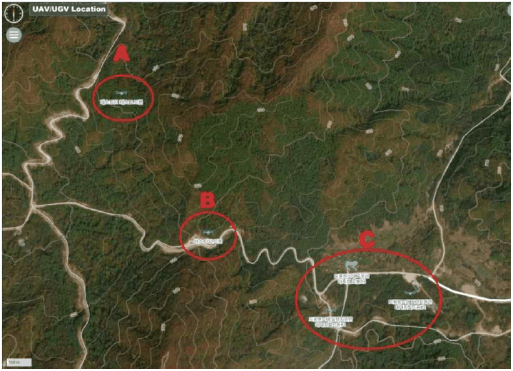
그림 2. | Fig. 2.
중계드론(A, B) 위치 및 정찰자산(C) 위치도 | Locations of relay UAVs (A, B) and reconnaissance assets (C).
Download Original Figure
링크 불안정은 중계 위치(1,016 m)와 정찰드론 사이에 위치한 약 995 m 높이의 고지대가 LOS(line-of-sight)를 차단한 것이 원인으로 분석되었고, 또한 중계드론 위치가 충분히 높더라도 정찰 드론 위치와 지리적 장애물이 주된 문제로 확인되었다.
4-1-2 2차 실험
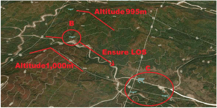
중계드론을 그림 2의 B 지점(고도 906 m, 드론 지상고 110 m(드론 해발고 1,016 m)에 배치하고 패널 안테나를 소폭(6°) 조정하여 지휘소부터 거리 4.6 km 조건에서 실험을 수행하였다(그림 3).
그림 3. | Fig. 3.
중계드론(A)과 정찰드론의 통신 링크가 불안정한 경우의 드론의 위치와 산악환경 | UAV positions and mountainous environment under an unstable communication link between relay UAV (A) and the reconnaissance UAV.
Download Original Figure
지휘소-중계드론 간 링크: SNR 16~20 dB, RSSI −70 dBm(통신링크 기준값)~−60 dBm 범위로 안정적 유지.
중계드론-정찰 링크: SNR 30 dB 수준에 RSSI −56 dBm으로 개선(그림 4).
그림 4. | Fig. 4.
중계드론(B)과 정찰드론의 통신 링크가 개선된 경우의 드론의 위치와 산악환경 | UAV positions and mountainous environment under an improved communication link between relay UAV (B) and the reconnaissance UAV.
Download Original Figure
4-2 실증 실험 결과 분석
산악지형 실증 실험에서 관측된 주요 결과(지형/LOS 영향, 위치·틸트 최적화 효과, 트래픽 병목)를 표 2 및 표 3에 요약하였다. 표 2에는 거리·LOS 조건·SNR·데이터 유형별 전송 품질 간 관계를 정리하였고, 표 3에는 운용 최적화 조치에 따른 성능 개선 정도를 제시하였다(그림 5).
표 2. | Table 2.
산악지형 전술 MANET 실험 결과 요약(LOS·링크 품질·트래픽) | Summary of mountainous tactical MANET field test results (LOS, link quality, and traffic).
| Category |
Applied link (segment) |
Distance (km) |
Terrain/LOS condition |
SNR/RSSI |
Data transmission result |
Interpretation |
| Failure (LOS blocked) |
Relay UAV-Recon UAV |
~3.9 |
A higher ridge (~995 m) near the relay-UAV position (elevation ~1,016 m AMSL) obstructed the propagation path |
≤11 dB/~−79 dBm |
|
Link quality was dominated by terrain-induced LOS blockage rather than distance |
| Relay repositioning (LOS secured) |
Command post-Relay UAV (and relay-assisted link) |
~4.6 |
The relay UAV was repositioned to secure LOS toward the command post |
≥30 dB/~−56 dBm |
|
Securing LOS substantially increased the link margin even at a longer distance |
| Traffic bottleneck (data-type effect) |
Traffic concentrated at relay node (Recon UAV/quadruped robot → Relay UAV) |
- |
Traffic-load effects were observed even under favorable LOS and link conditions |
Link quality favorable |
|
Channel capacity/occupancy becomes a key bottleneck for multi-stream video transmission |
Download Excel Table
표 3. | Table 3.
운용 최적화(위치 조정·안테나 틸트)에 따른 성능 개선 효과 | Impact of operational optimizations (relocation and antenna tilt) on link performance.
| Optimization action |
Applied link (segment) |
Adjustment |
Before (SNR) |
After (SNR) |
Implications |
| Relay UAV position adjustment |
Relay UAV-Recon UAV |
Move ~30 m toward the command post near the link-threshold region |
10~11 dB |
Improved by ~15 dB |
Mountainous terrain is sensitive to local propagation-path changes; on-site relocation criteria are required |
| Command-post antenna tilt adjustment |
Command post-Relay UAV |
Slightly up-tilt the command-post panel antenna (+6°) |
Unstable (low sensitivity) |
Stable at 16~20 dB |
Geometric alignment reflecting elevation differences is effective |
Download Excel Table
Ⅴ. 결 론
본 연구에서는 산악지형 실증 실험을 통해 MANET 기반 통신기술 체계가 LOS 확보 및 안테나 운용 최적화(틸트·배치)를 전제로 4 km 이상 거리에서도 20 dB 이상의 안정적인 링크 품질을 확보할 수 있음을 확인했다.
실험 결과, 통신 품질은 노드 간 거리보다 지형 장애물에 따른 LOS 확보 여부에 더 크게 좌우되었고, 중계드론 위치의 조정과 지휘소 안테나 틸트 미세 조정을 통해서 SNR과 링크 안정성을 개선할 수 있음을 확인했다.
반면 단일 중계 방식은 지형 차폐로 인한 음영구역과 기상 요인에 따른 체공 안정성 저하의 한계가 확인됐으며, 다중 영상 전송 시 가용 대역폭 초과로 프레임 드롭과 지연이 발생할 수 있음을 확인했다.
향후에는 다중 홉 기반 메쉬 네트워크 구성과 QoS 적용의 영향성 연구와 프레넬 존을 고려한 안테나 배치 최적화를 통해 생존성과 전송 안정성에 대한 연구가 필요하다.
Acknowledgements
이 연구는 2024년 정부(방위사업청, 국방기술진흥연구소의 방산혁신기업 100 프로젝트 기술개발전용지원사업)의 재원으로 국방기술진흥연구소의 지원을 받아 수행된 연구임(R240203).
References
M. Harayama, M. Nishioka, and T. Hayashi, “3-D simulation of MANET with UAV in mountainous areas,” in
2020 35th International Technical Conference on Circuits/Systems, Computers and Communications(ITC-CSCC), Nagoya, Jul. 2020, pp. 166-171.

S. M. Al-Shehri, P. Loskot, and M. J. Hirsch, “Enabling connectivity for tactical networks in mountainous areas by aerial relays,”
Telecommunication Systems, vol. 71, no. 4, pp. 561-575, Aug. 2019.

Y. Kim, Y. Lee, J. Jeon, J. Choi, S. Park, B. C. Jung, and H. Lee, “Performance analysis of probabilistic relay UAV selection method considering neighbor UAV characteristics in FANETs,”
The Journal of Korean Institute of Communications and Information Sciences, vol. 49, no. 5, pp. 748-751, May 2024.
M. El Debeiki, S. Al-Rubaye, A. Perrusquia, C. Conrad, and J. A. Flores-Campos, “An advanced path planning and UAV relay system: Enhancing connectivity in rural environments,”
Future Internet, vol. 16, no. 3, p. 89, Mar. 2024.